

Anthony Lomax @ALomax@social.cleverlibre.org
#Earthquake happenings+tidbits, maps, #MachineLearning... I'm ALomax Scientific: earthquake monitoring and analysis.
"seismicity is only the edges and shadows of complex, 3D space-time tectonic processes"
Car free for daily life since 1976.
Joined Nov 2022
Anthony Lomax
boosted

#EarthquakeReport #EarthquakeToot #TsunamiReport #TsunamiToot for M7.0 #Earthquake offshore of #SolomonIslands
Australia plate extensional (normal) fault
small tsunami at Honiara tide gage
report forthcoming
Read more in 2017 report here
https://earthjay.com/?p=5182
https://earthquake.usgs.gov/earthquakes/eventpage/us7000irfb/dyfi/intensity
Anthony Lomax
boosted

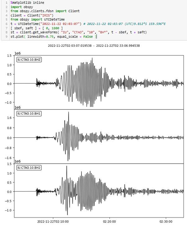
This happened in the night my time: magnitude 7 #earthquake in the #SolomonIslands (2022-11-22Z02:03) Signal on station IU.CTAO (Charters Towers, Australia) Incredible #surfacewaves - it was quite a shallow event. Damage to buildings and power out (c.f. the Guardian: https://www.theguardian.com/world/2022/nov/22/tsunami-warning-after-70-magnitude-earthquake-near-solomon-islands)
https://earthquake.usgs.gov/earthquakes/eventpage/us7000irfb/executive
Anthony Lomax
boosted
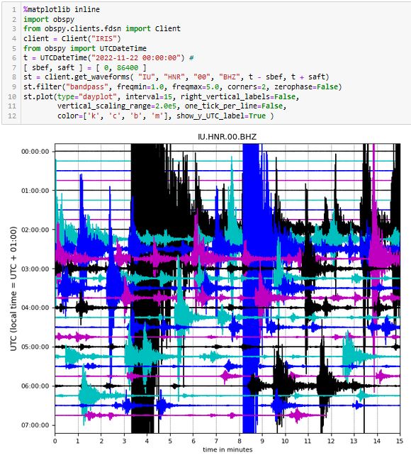
There is quite an intensive #aftershock sequence following the #SolomonIslands #Earthquake This is a "mock helicorder plot" from the station IU.HNR (Honiara, Solomon Islands). The data is made freely available via #IRIS and is plotted using the free and open @obspy software. https://earthquake.usgs.gov/earthquakes/eventpage/us7000irfb/executive
Anthony Lomax
boosted

According to posts on twitter, there are significant damages and at least 2 fatalities after a moderate magnitude M5.6 #earthquake in western Java island, Indonesia. Inland shallow fault rupture, close to towns, likely explain the destructions.
RT 👇🏼 https://twitter.com/BNPB_Indonesia/status/1594596756205244418?s=20&t=N0QFeOPMmCQp1ReAfiCnjw
and
https://twitter.com/pamumpuni/status/1594599955037028354?s=20&t=N0QFeOPMmCQp1ReAfiCnjw
Anthony Lomax
boosted
#EarthquakeReport #EarthquakeToot for M5.6 #Gempa #Earthquake in #Java #Indonesia South of #Jakarta
Reports of intensity MMI 7
May be damage, appears shallow but depth currently set at default 10km
Read more from report for event in 2017
https://earthjay.com/?p=6602
https://earthquake.usgs.gov/earthquakes/eventpage/us7000ir9t/dyfi/intensity
Anthony Lomax
boosted
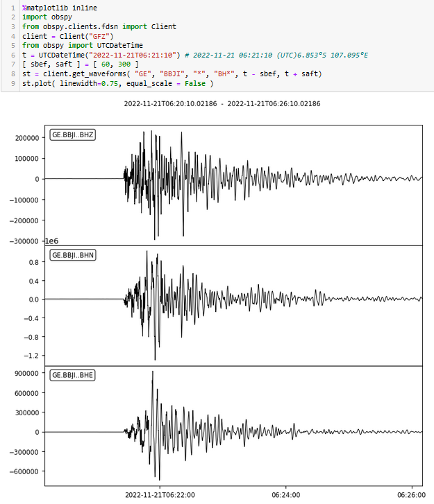
Magnitude 5.6 #earthquake on #Java #Indonesia about one hour ago (2022-11-2ZT06:21) a little south of #Jakarta. There are reports of damage. Signal on station GE.BBJI (Bungbulang, Garut, Java) courtesy of @geofon and displayed using @obspy software. I hope that damage and injuries are limited. https://earthquake.usgs.gov/earthquakes/eventpage/us7000ir9t/executive
Anthony Lomax
boosted

So main #COP27 achievements are an as-yet-unfunded commitment to loss and damage and not quite backsliding on some of the commitments from COP26. Doesn’t really feel like we’re collectively meeting the moment, does it? https://www.theguardian.com/environment/2022/nov/20/cop27-climate-summit-egypt-key-outcomes
Anthony Lomax
boosted

Without any binding commitments to rapidly and immediately reduce greenhouse gases, the world stands no chance to deliver on the 1,5°C limit, and by doing so minimising risks of uprooting the life supporting systems we all depend on and endangering countless human lives.
#COP27
Anthony Lomax
boosted

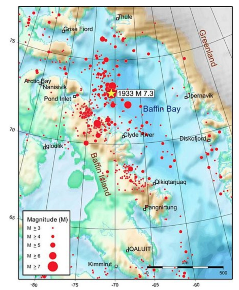
Nov. 20, 1933: A M7.3 earthquake struck offshore Baffin Island, #Canada.
This is the largest known #earthquake along the passive margin (east/north coasts) of #NorthAmerica and the largest (known) earthquake north of the Arctic Circle.
More information: https://seismescanada.rncan.gc.ca/historic-historique/events/19331120-en.php
https://seismescanada.rncan.gc.ca/historic-historique/events/ABent2002baffinbay1933.pdf
Anthony Lomax
boosted
A magnitude Mw6.9 #earthquake offshore south-central #Sumatra.
Mechanism and location suggest rupture on the shallow part of the #subduction #megathrust close to the trench (on the very shallow dipping fault plane). However, modelled depth of ~19km, if true, seems little too deep given the closeness with the trench (USGS gives same depth and mechanism). This means that we cannot exclude a rupture on the steep fault plane within the oceanic plate.
Map with source time function from Geoscope IPGP
http://geoscope.ipgp.fr/index.php/en/catalog/earthquake-description?seis=us7000iqpn
Larger map with epicenter of this event in red from USGS (both not yet on fediverse it seems)
Earthquake First-motion Focal mechanisms explained https://www.youtube.com/watch?v=MomVOkyDdLo
Location and First-motion mechanism: Mwp6.8 #earthquake Southwest of Sumatra, Indonesia http://early-est.alomax.net http://alomax.free.fr/projects/early-est/events/hypo.1668778608226.html
Anthony Lomax
boosted

 🇳🇱
🇳🇱
I never expected Musk to go to such great lengths to promote the fediverse.... but here we are.
Anthony Lomax
boosted

So this is my first post on Mastodon.
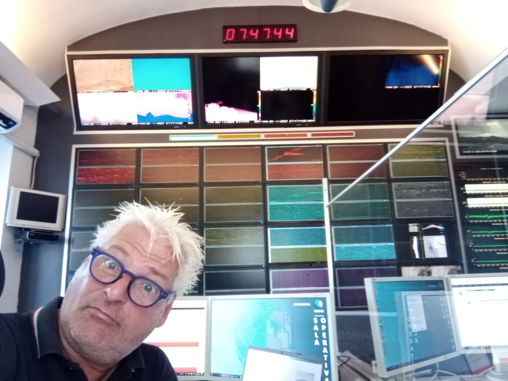
Part of my work as a volcanologist with the Italian National Institute of Geophysics and Volcanology (Istituto Nazionale di Geofisica e Vulcanologia, INGV) is the real-time surveillance of seismic and volcanic activity in the volcanic areas of Sicily. This is done in 8-hour shifts in the Operations Room of the INGV seat in Catania, the Osservatorio Etneo. This is me making a stupid face during my latest shift, on 5 November 2022.
Anthony Lomax
boosted

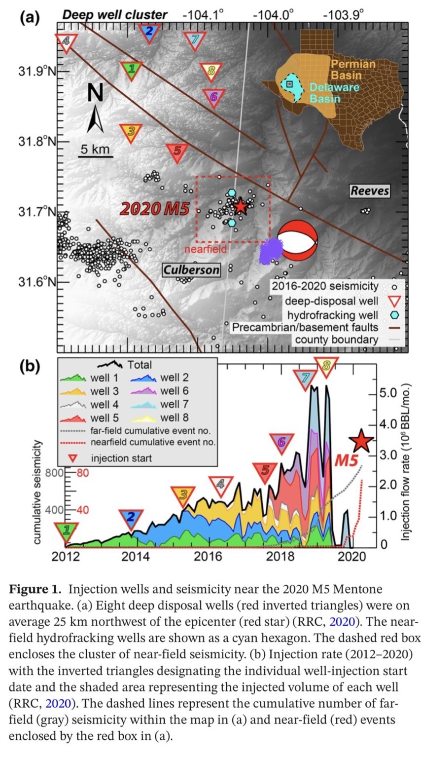
Today’s #Texas M5.4 #earthquake (approximate location as a purple blob) in the context of nearby #reinjection wells and other recent #earthquakes on a map from Tung et al. (2020)
Anthony Lomax
boosted

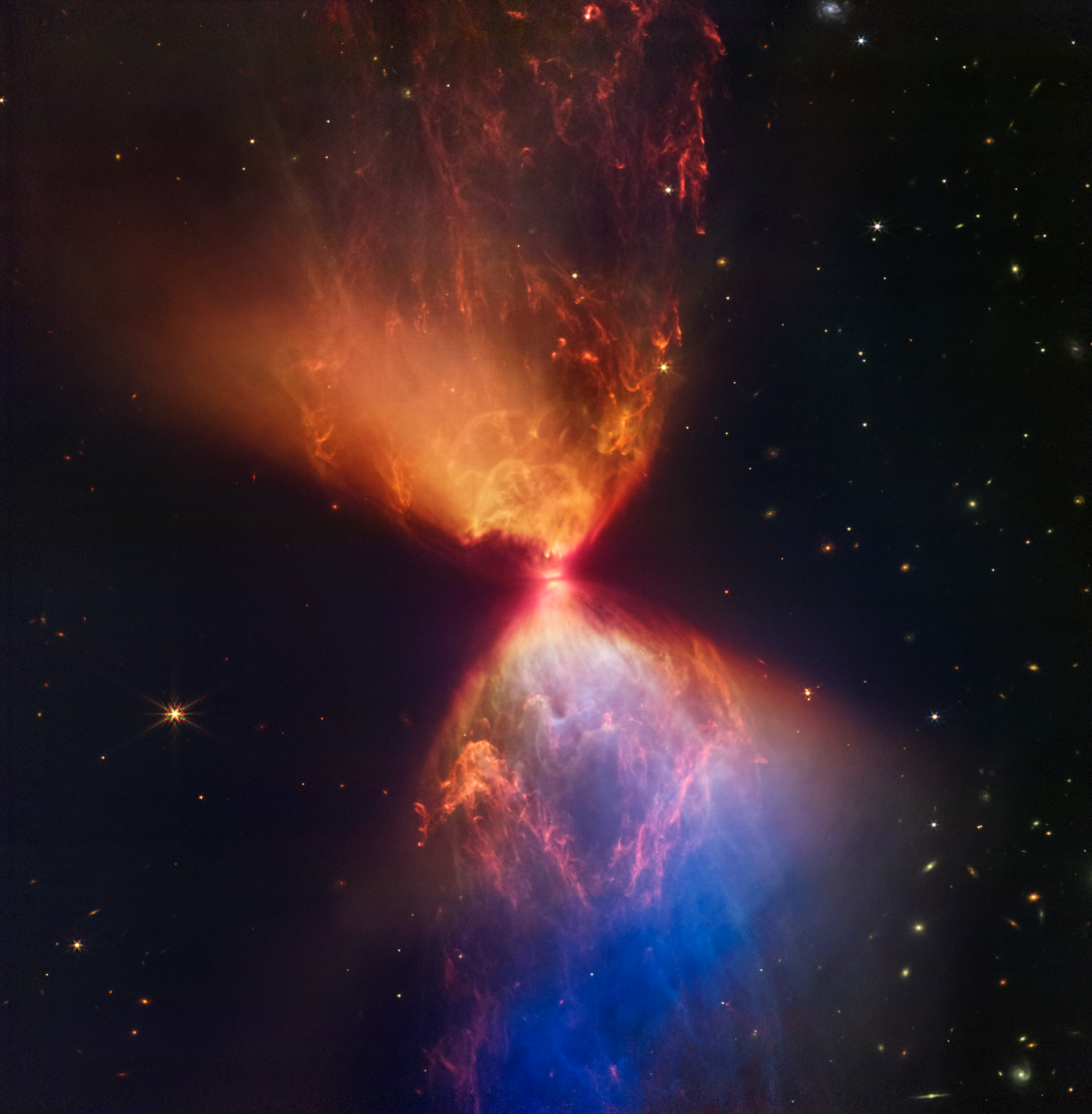
Look closely at the center of this image. You probably noticed the bright spot in the center, the central protostar. But did you notice the dark band in front of it? That’s the protostar’s accretion disk, created as material swirls around it.
The material within this disk can sometimes clump up, forming the beginnings of planets. But the protostar will absorb many of these before they can mature.
Credit: NASA, ESA, CSA, and STScI
Anthony Lomax
boosted
This thread by @rvawonk digs into how central Twitter has become to relaying information during disasters, how terrible it will be to suddenly lose it.
https://twitter.com/RVAwonk/status/1592347386684506113
Yep, still angry about it.
Anthony Lomax
boosted

@jbrussell @CopernicusEU This is #Etna #volcano, whose eastern flank is slowly moving towards the east as a result of gravitational forces and upwelling of #magma from under the volcano. Magma injection also occur regularly at the volcano summit, feeding #lava flows and #eruptions, further increasing deformation. This is easily visible with #InSAR. See De Novelis et al 2019 paper, which focuses on the Dec 2018 #eruption: https://scholar.google.com/scholar?cluster=8685606862432434928&hl=fr&as_sdt=2005&sciodt=0,5#d=gs_qabs&t=1668609673277&u=%23p%3DUHTlOdd2JJMJ
Anthony Lomax
boosted

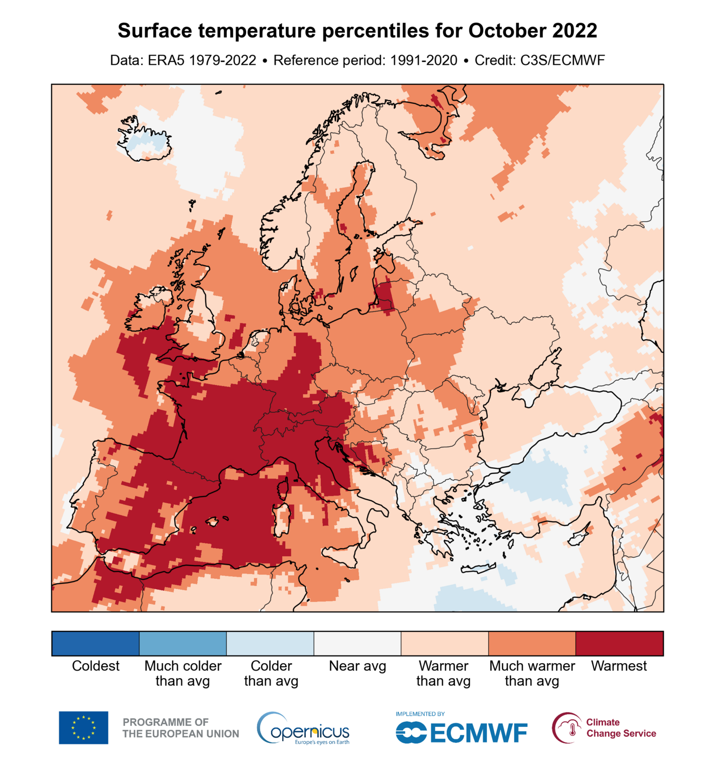
In Europe, October 2022 was by far the warmest ever recorded, beating the previous record by over 0.5⁰C!
https://climate.copernicus.eu/surface-air-temperature-october-2022
Anthony Lomax
boosted







@stevenjgibbons JMA seismic intensity maps show the greatest intensity far from the epicenter (360km deep, so Pacific Plate related). In Japanese the phenomenon of feeling a quake more strongly farther from the epicenter is called 異常震域, unusual tremor area. Do we have an English word for it?
#Earthquake happenings+tidbits, maps, #MachineLearning... I'm ALomax Scientific: earthquake monitoring and analysis.
"seismicity is only the edges and shadows of complex, 3D space-time tectonic processes"
Car free for daily life since 1976.
Joined Nov 2022
