

Jason R. Patton @earthjay@social.cleverlibre.org
- eq Reports
- https://earthjay.com
lover of mud, sand, gravel, chocolate and Earthquake Reports at https://earthjay.com
Joined Nov 2022
Jason R. Patton
boosted

#EarthquakeReport #TsunamiReport #EarthquakeToot #TsunamiToot for M 6.9 #Gempa #Earthquake offshore of #Sumatra #Indonesia
Cocos Isle gage updated due to twitter peer review from Harold Tobin thanks!
also added Bintuhan record
interp poster and plots updated in report here
https://earthjay.com/?p=10545
Jason R. Patton
boosted

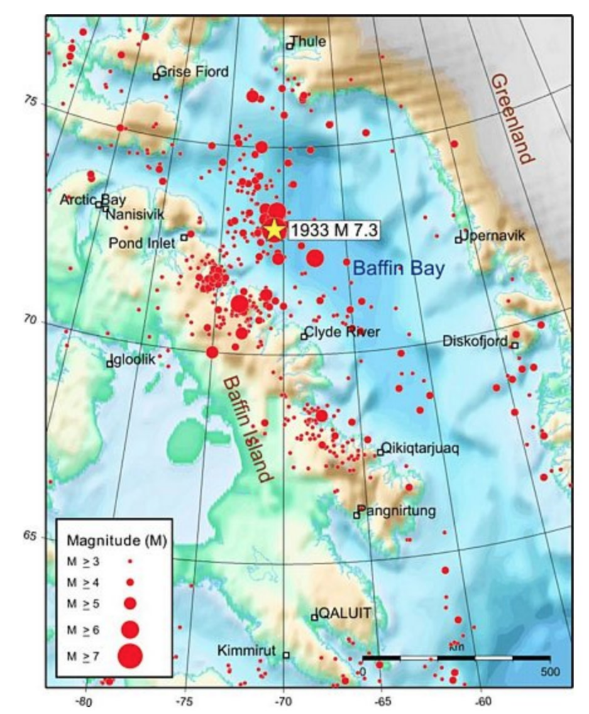
Nov. 20, 1933: A M7.3 earthquake struck offshore Baffin Island, #Canada.
This is the largest known #earthquake along the passive margin (east/north coasts) of #NorthAmerica and the largest (known) earthquake north of the Arctic Circle.
More information: https://seismescanada.rncan.gc.ca/historic-historique/events/19331120-en.php
https://seismescanada.rncan.gc.ca/historic-historique/events/ABent2002baffinbay1933.pdf
Jason R. Patton
boosted

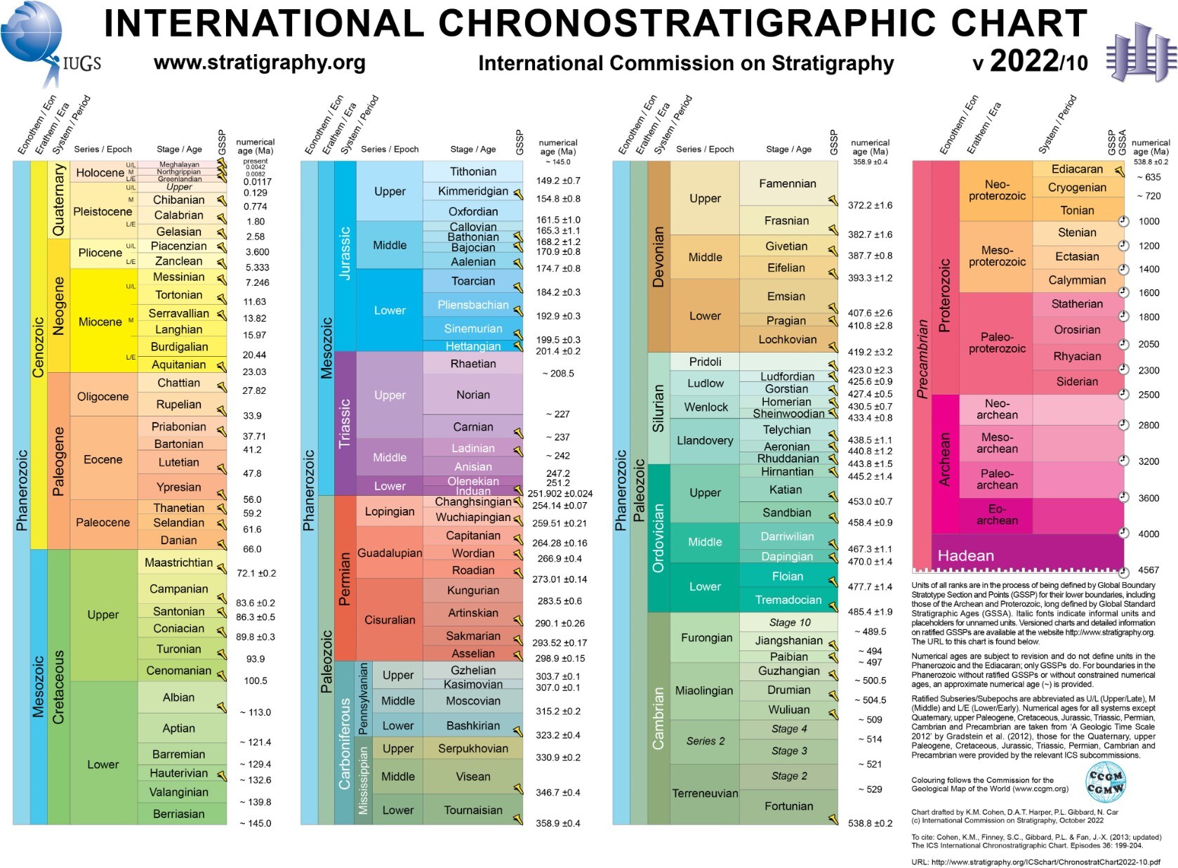
New Chronostratigraphic Chart from the International Commission on Stratigraphy:
https://stratigraphy.org/news/143
Jason R. Patton
boosted

A few years ago I made this flow chart of which Mastodon posts end up in which timelines!
So, you can see how each instance will have a different local timeline, and even a slightly different federated timeline - and you can see why the federated timeline moves so much faster than the local one, too.
This is why it's important to boost good posts and use hashtags - the fediverse is fragmented and harder to search by nature.
Jason R. Patton
boosted

There's a bit of a storm happening around the criteria for joining http://fediscience.org - the Mastodon instance for scientists, on which I'm hosted.
It's been noted that the requirement to be a publishing scientist (who has published in the past 5 years) will exclude many junior scientists, retired sciences, and those who have maybe switched to teaching.
I agree with these concerns and wonder if the criteria can be changed to be more inclusive?
Jason R. Patton
boosted

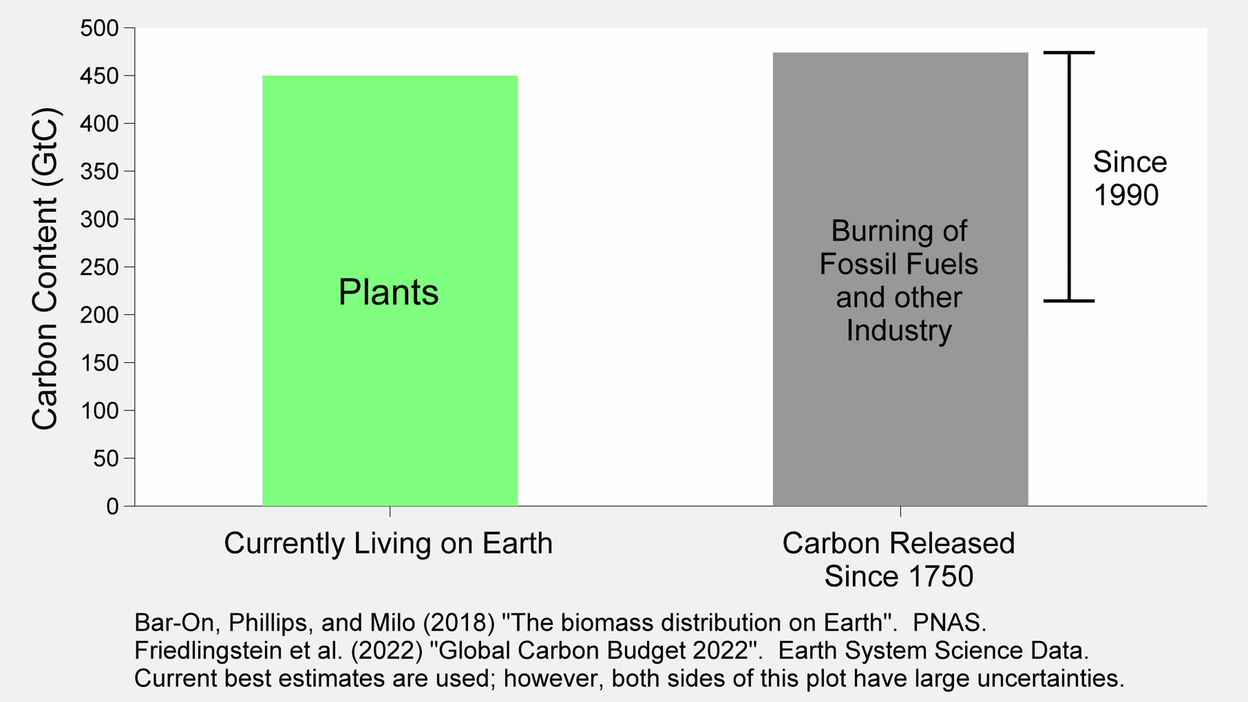
Through the burning of fossil fuels, humans have released more carbon into the atmosphere than is contained in all of the plants currently living on Earth.
More than half of this has occurred since 1990.
We are transforming the Earth and the atmosphere on a truly massive scale.
Reforestation, and other natural solutions, will never match the scale of the problem without substantial emissions reductions.
Jason R. Patton
boosted

Focal Mechanisms Explained: What are those “beach balls”? by
IRIS Earthquake Science
https://youtu.be/MomVOkyDdLo
Jason R. Patton
boosted

Tectonic stress change due to the 2011 Tohoku earthquake inferred from long-term CMT data of regular earthquakes
Toshiko Terakawa, Mitsuhiro Matsu'ura, Tectonic stress fields inferred from long-term CMT data ranging over different periods, Geophysical Journal International, 2022;, ggac449, https://doi.org/10.1093/gji/ggac449
Jason R. Patton
boosted

It's hard to overstate how much fuel the failure of the DOJ to hold the former WH occupant accountable for his role in the Jan. 6 insurrection & theft of classified documents (among others) causes the MAGA crowd to aggressively assert he's done nothing wrong. That is: No charges=No Crimes.
Jason R. Patton
boosted

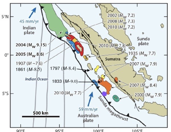
Today’s M6.9 shallow #megathrust #earthquake (approximate location as purple blob) in the context of the #rupture areas of (numerous) previous #subduction events near #Sumatra on a map from Putra et al. (2016)
Jason R. Patton
boosted

Testing out this platform. Do video clips of lava work? Here is one I shot from Iceland last year. Is it a still or video?
Jason R. Patton
boosted

The brilliant Dr Sarah Crump passed away peacefully on Friday - Sarah #inspired so many of us and to further her #legacy #INSTAAR has started a #fellowship in her name to help future students #arctic #alpine Please consider giving if you can https://www.colorado.edu/instaar/instaar-resources/student-funding/sarah-crump-graduate-fellowship
#EarthquakeReport #EarthquakeToot for M 6.9 #Gempa #Earthquake offshore of #Sumatra #Indonesia
probably slip along megathrust subduction zone where Chlieh modeled low seismogenic coupling https://doi.org/10.1029/2007JB004981
*in area absent of GPS/microatoll data
read more here:
https://earthjay.com/?p=10545
Jason R. Patton
boosted

My most well known photo from the field, and well timed being very nearly the anniversary of the 2016 Kaikoura Earthquake sequence. This is the "Wall of Waiau" on the Leader fault. This scarp is actually a bit of a quirk of nature, no prior rupture here and effective localised normal movement due to topography on an oblique thrust and right lateral fault.
#geology #fault #earthquake #photography #EarthScience #nz
#EarthquakeReport #EarthquakeToot for M 6.9 #Gempa #Earthquake offshore of #Sumatra #Indonesia
appears to be a megathrust subduction zone fault earthquake
generated a small tsunami recorded on tide gages
read more here:
https://earthjay.com/?p=10545
#EarthquakeReport #EarthquakeToot for M6.9 #Gempa #Earthquake offshore of #Sumatra #Indonesia
Appears to be on the megathrust subduction zone fault
Read more about the regional tectonics here
https://earthquake.usgs.gov/earthquakes/eventpage/us7000iqpn/executive
Jason R. Patton
boosted





@SakuRainbow @earthjay Interestingly, you can look at different solutions for the the same earthquake (M7.3 #Tonga shallow #earthquake of 11 Oct), depending on the inversion method: https://earthquake.usgs.gov/earthquakes/eventpage/us7000ip0l/moment-tensor.


Jason R. Patton
boosted
@SakuRainbow @earthjay Actually, the rounded parts show that the moment tensor is not 100% consistent with pure slip on a planar fault ("pure double couple"). But maybe 10% is unexplained. The rest can be due to 1/ uncertainty in the inversion, 2/ actual complexity of the rupture (multiple faults activated, roughness of the fault...) or 3/ volume change (e.g. when magma is involved). #SCARDEC assumes a pure fault plane, whereas #USGS leaves more freedom to inversion. See https://pubs.er.usgs.gov/publication/70020193
Jason R. Patton
boosted
- eq Reports
- https://earthjay.com
lover of mud, sand, gravel, chocolate and Earthquake Reports at https://earthjay.com
Joined Nov 2022
