

🎓 Dr. Freemo  🇳🇱
@freemo@social.cleverlibre.org
- UFoI Member
- http://UFoI.org/u/freemo/
- Website
- http://JeffreyFreeman.me
- Gitlab
- https://git.qoto.org/freemo
Admin
Jeffrey Phillips Freeman
Innovator & Entrepreneur in Machine Learning, Evolutionary Computing & Big Data. Avid SCUBA diver, Open-source developer, HAM radio operator, astrophotographer, and anything nerdy.
Born and raised in Philadelphia, PA, USA, currently living in Utrecht, Netherlands, USA, and Thailand. Was also living in Israel, but left.
Pronouns: Sir / Mister
(Above pronouns are not intended to mock, i will respect any persons pronouns and only wish pronouns to show respect be used with me as well. These are called neopronouns, see an example of the word "frog" used as a neopronoun here: http://tinyurl.com/44hhej89 )
A proud member of the Penobscot Native American tribe, as well as a Mayflower passenger descendant. I sometimes post about my genealogical history.
My stance on various issues:
Education: Free to PhD, tax paid
Abortion: Protected, tax paid, limited time-frame
Welfare: Yes, no one should starve
UBI: No, use welfare
Racism: is real
Guns: Shall not be infringed
LGBT+/minorities: Support
Pronouns: Will respect
Trump: Moron, evil
Biden: Senile, racist
Police: ACAB
Drugs: Fully legal, no prescriptions needed
GPG/PGP Fingerprint: 8B23 64CD 2403 6DCB 7531 01D0 052D DA8E 0506 CBCE
Joined Jul 2018
@astrotoot@mastodon.online yea this genre of games never gives enough attention to the roundness of their dice circles, I agree.
@astrotoot@mastodon.online nice, let me know your favorite part.. mine is the color test palette, it has all the colors!
@astrotoot@mastodon.online dude testgame reseller product is awesome... your just jelly you dont own it!
@stux A lot of plants do this, including leaves. In fact it is often a way to identify certain plants.
For example jewelweed does this (the leaves) and is identified by taking a leafe and dipping it in a river. If it shines like silver (for the layer of air on the leaf) its jewel weed. Useful to know as its an amazing cure in my expiernce for poison ivy.
@FailForward I was taught as a kid about river flows that empty into two separate watersheds (I had a strong ecology education in highschool and below). So while I knew there were about 2 dozen such occurrences worldwide I actually couldn't remember many of them.. So I tried to do some research and find a list to refresh my memory, i didnt find anything at first but finally just found this list, it looks fairly complete:
https://en.wikipedia.org/wiki/List_of_unusual_drainage_systems
What field are you and your partner looking for work in. I'd be happy to see if I can pull any strings for either of you and help with your job search.
@FailForward Not all of those flow into entirely separate oceans mind you, but they do bifurcate between different watersheds at a minimum.
@FailForward They are in fact fairly rare if we are talking only natural occurrences. Only about two dozen such occurrences worldwide as far as I know.
@hanswolters I've always been a nature buff, I love this stuff. Its always way more complicated then we can imagine, nature is amazing like that.
@hanswolters In short, the rivers will tend to lie perpendicular to the altitude lines on a topographic map and generally grow larger the more lines they pass through.
@hanswolters FYI if you took these maps and overlaid them on a topographic map you'd find there is a very close relationship between them. In all likelihood the boundary between the 4 main (largest) colored areas would have the ridge of a mountain running along it which divides the waterflow down either face. The larger rivers will almost always exist in the lowest lying areas as well, the valleys below the mountains.
@hanswolters Happy to help. (by the way not getting notified of these replies, but thats normal as I dont seem to be tagged. Even the OP likely isnt seeing your replies).
@hanswolters Its a chart of watersheds.. each color ultimately flows into a single main river and a single outlet into the ocean.. so each color corresponds to one place water flows into an ocean.
I attached the german part of the map zoomed in for you.
I shared this in a reply recently but thought the information and maps might be neat on my main timeline...
Here is one of my favorite maps showing water ways (attached), the coloring is significant.
Each unique color represents a watershed, that is each color all drains out in the same direction and to the same point, ultimately draining to a single outlet into an ocean. You can always get from any point in the same color to any other point.
WRT a waterway which connects from ocean to ocean that would occur anytime there is a point that sits between two colors, almost always a lake, that drains off into each color in different directions. These lakes are special in the sense that they are the relatively rare waterways that belong to two or more watersheds.
@FailForward While we are on the topic here is one of my favorite maps showing water ways (attached), the coloring is significant.
Each unique color represents a watershed, that is each color all drains out in the same direction and to the same point, ultimately draining to a single outlet into an ocean. You can always get from any point in the same color to any other point.
WRT a waterway which connects from ocean to ocean that would occur anytime there is a point that sits between two colors, almost always a lake, that drains off into each color in different directions. These lakes are special in the sense that they are the relatively rare waterways that belong to two or more watersheds.
@FailForward Yes there is. Probably more than one but the one I know about goes from the netherlands to romania as a continuous waterway. In fact there is a third leg connected to this river that can divide europe into 3 parts not just 2
🎓 Dr. Freemo 🇳🇱
boosted
🇳🇱
boosted


Fascinating. Is there such a thing in Europe? I am not aware...

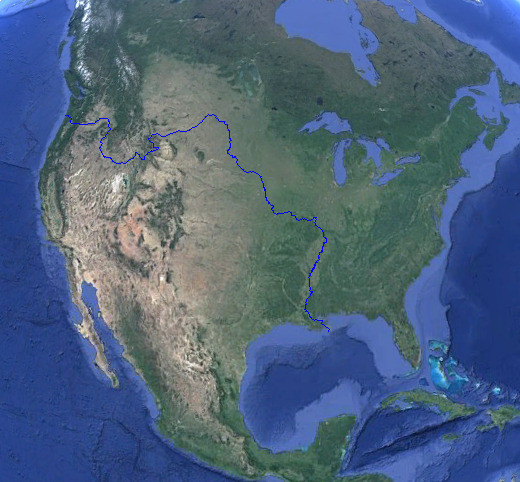
The river connecting two oceans: A creek in Wyoming splits in two, one side flowing to the Atlantic and one side to the Pacific. You can’t pass the...
@louiscouture That would do it alright :)

I'd like to see flat earthers explain this picture (it isnt edited).

- UFoI Member
- http://UFoI.org/u/freemo/
- Website
- http://JeffreyFreeman.me
- Gitlab
- https://git.qoto.org/freemo
Admin
Jeffrey Phillips Freeman
Innovator & Entrepreneur in Machine Learning, Evolutionary Computing & Big Data. Avid SCUBA diver, Open-source developer, HAM radio operator, astrophotographer, and anything nerdy.
Born and raised in Philadelphia, PA, USA, currently living in Utrecht, Netherlands, USA, and Thailand. Was also living in Israel, but left.
Pronouns: Sir / Mister
(Above pronouns are not intended to mock, i will respect any persons pronouns and only wish pronouns to show respect be used with me as well. These are called neopronouns, see an example of the word "frog" used as a neopronoun here: http://tinyurl.com/44hhej89 )
A proud member of the Penobscot Native American tribe, as well as a Mayflower passenger descendant. I sometimes post about my genealogical history.
My stance on various issues:
Education: Free to PhD, tax paid
Abortion: Protected, tax paid, limited time-frame
Welfare: Yes, no one should starve
UBI: No, use welfare
Racism: is real
Guns: Shall not be infringed
LGBT+/minorities: Support
Pronouns: Will respect
Trump: Moron, evil
Biden: Senile, racist
Police: ACAB
Drugs: Fully legal, no prescriptions needed
GPG/PGP Fingerprint: 8B23 64CD 2403 6DCB 7531 01D0 052D DA8E 0506 CBCE
Joined Jul 2018
