

🎓 Dr. Freemo  🇳🇱
@freemo@social.cleverlibre.org
- UFoI Member
- http://UFoI.org/u/freemo/
- Website
- http://JeffreyFreeman.me
- Gitlab
- https://git.qoto.org/freemo
Admin
Jeffrey Phillips Freeman
Innovator & Entrepreneur in Machine Learning, Evolutionary Computing & Big Data. Avid SCUBA diver, Open-source developer, HAM radio operator, astrophotographer, and anything nerdy.
Born and raised in Philadelphia, PA, USA, currently living in Utrecht, Netherlands, USA, and Thailand. Was also living in Israel, but left.
Pronouns: Sir / Mister
(Above pronouns are not intended to mock, i will respect any persons pronouns and only wish pronouns to show respect be used with me as well. These are called neopronouns, see an example of the word "frog" used as a neopronoun here: http://tinyurl.com/44hhej89 )
A proud member of the Penobscot Native American tribe, as well as a Mayflower passenger descendant. I sometimes post about my genealogical history.
My stance on various issues:
Education: Free to PhD, tax paid
Abortion: Protected, tax paid, limited time-frame
Welfare: Yes, no one should starve
UBI: No, use welfare
Racism: is real
Guns: Shall not be infringed
LGBT+/minorities: Support
Pronouns: Will respect
Trump: Moron, evil
Biden: Senile, racist
Police: ACAB
Drugs: Fully legal, no prescriptions needed
GPG/PGP Fingerprint: 8B23 64CD 2403 6DCB 7531 01D0 052D DA8E 0506 CBCE
Joined Jul 2018
@LouisIngenthron @thegonzoism @trinsec
As ive stated, if balanced correctly (the numbers need twesking sometines) then yes. It prevents a tyranny of the minority as discussed. It ensures the various cultures we have who are small isolated groups (like the amish) dont get thrown under a bus for the whims of the majority
@LouisIngenthron @thegonzoism @trinsec
No they arent elected the same.
In the house the number of seats per stste is based on population, bigger get more. The senate is fixed with each stste getting 2 and only 2. This ensures states that have low populations and are mostly red states in this case, get more representstion per person.
@trinsec @LouisIngenthron @thegonzoism
Thry do it all the time... yes the map can and will be abused. But thats not what is being done here.
It makes one simple fact clear, if you drive to almost any random place in america, you are almost always surrounded by red voters. Only time your not is if its a city.
@TruthSandwich @freepeoplesfreepress
It coukd be used to oush the notion that thr bulk ofnpeople 8n the coubtry lean red, sure.. its not being used like thst here, however, as has been stated.
@LouisIngenthron @thegonzoism @trinsec
Its not misleading at all, its intent as ststed clearly is to show votes by land mass. Nothibg misleading about that, no one is claiming this is showing votes by population density, its showing votes by region only.
We arent talki g racial minorities, we are talking american cultures. Southern culture, amish terretories, mennonite terretories, etc. Its not about race, wrong sort of minority in this context.
The logic works fine, there are senators that represent those other areas and their culture, so its fine. We also balance that out in a different way, by adding a fixed number of sentators as a base and then addind more due to population. This evens out the densities in a similar way.
@TruthSandwich @freepeoplesfreepress
Thats not misleading thst is the intent of the map.. it isnt intended to show how many people voted.
@thegonzoism @LouisIngenthron @trinsec
The following map is not gerrymandered and shows color intensity based on how strongly it leans... still looks pretty similar.

@trinsec @thegonzoism @LouisIngenthron
Sadly no it wont.
@LouisIngenthron @thegonzoism @trinsec
As well it shoukd be. The oresident resides over all regions and as such should be accepted by all cultures and regions. He should be discouraged from throwing minority cultures under a bus.
A congressman only has to represent his one district, he is local in nature, so he doesnt have to consider diverse cultures across different states and regions as he covers a small local area.
@trinsec @thegonzoism @LouisIngenthron
Gerry mandering is a seperate issue which inagree shoukd be addressed.
@thegonzoism @LouisIngenthron @trinsec
We have electorial colleges in the usa, so no it isnt one person one vote. We do this to ensure the interest of all groups and cultures must be considered and grouos that respresent minorities are less likely to be abused. Makes sense to me.
When talki g about effects on the masses your individual expiernce isnt important... we know from countless psychological studies that people behave worse in high population crowded areas. Even mouse experiments show unhealthy behavior rising when there is overcrowding.
@casastorta then hour just flat out wrong by the data...
@freepeoplesfreepress @TruthSandwich
Atta hed a more accurate one for ya... same results, and a well respected source this time.
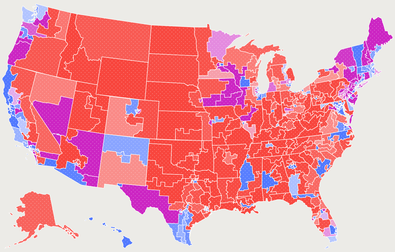
@trinsec Sure this one does that, sorta. Its not a specific year but rather shows the average way a coubty votes. Purple is 50/50 the brighter the red the larger its vote on average towards republican (more people voting consistently)

@casastorta yes that woukd be suburbs, the live near people but arent under u healthy population density... those are generally red too.
Also note even the defi ition you provided entierly agrees with me on both definition a and b.
@TruthSandwich You are rivht, you do t. Here is the oxford dictionary definition.
a system of government by the whole population or all the eligible members of a state, typically through elected representatives.
@mapto no these arent congressional districts, so gerrymandering doesnt effect this map. It is based off the popular lean in counties.
- UFoI Member
- http://UFoI.org/u/freemo/
- Website
- http://JeffreyFreeman.me
- Gitlab
- https://git.qoto.org/freemo
Admin
Jeffrey Phillips Freeman
Innovator & Entrepreneur in Machine Learning, Evolutionary Computing & Big Data. Avid SCUBA diver, Open-source developer, HAM radio operator, astrophotographer, and anything nerdy.
Born and raised in Philadelphia, PA, USA, currently living in Utrecht, Netherlands, USA, and Thailand. Was also living in Israel, but left.
Pronouns: Sir / Mister
(Above pronouns are not intended to mock, i will respect any persons pronouns and only wish pronouns to show respect be used with me as well. These are called neopronouns, see an example of the word "frog" used as a neopronoun here: http://tinyurl.com/44hhej89 )
A proud member of the Penobscot Native American tribe, as well as a Mayflower passenger descendant. I sometimes post about my genealogical history.
My stance on various issues:
Education: Free to PhD, tax paid
Abortion: Protected, tax paid, limited time-frame
Welfare: Yes, no one should starve
UBI: No, use welfare
Racism: is real
Guns: Shall not be infringed
LGBT+/minorities: Support
Pronouns: Will respect
Trump: Moron, evil
Biden: Senile, racist
Police: ACAB
Drugs: Fully legal, no prescriptions needed
GPG/PGP Fingerprint: 8B23 64CD 2403 6DCB 7531 01D0 052D DA8E 0506 CBCE
Joined Jul 2018
